|
|
You are not currently logged in. Are you accessing the unsecure (http) portal? Click here to switch to the secure portal. |
|
|
Do you have permission to re-use this image? Just because scans appear on Wiktenauer does not mean that they are free to use. Wiktenauer is a 501(c)(3) nonprofit, and many of the scans we host are only licensed for nonprofit use. In other cases, the scans have no standard license and Wiktenauer has received special permission to host them (and can't grant that permission to anyone else). The license terms appear in the Copyright and License Terms box at the bottom of the page that sent you here. When in doubt, always check with the museum or library that owns a manuscript before publishing or otherwise reusing its scans. |
File:Dutch East Indies Expansion.png
Jump to navigation
Jump to search

Size of this preview: 800 × 387 pixels. Other resolutions: 320 × 155 pixels | 923 × 447 pixels.
Original file (923 × 447 pixels, file size: 80 KB, MIME type: image/png)
Summary
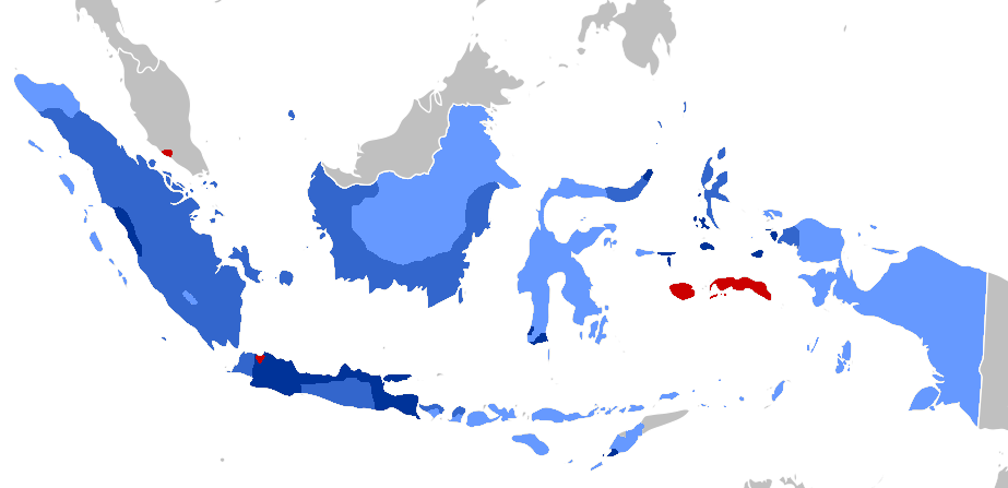
| Description |
Afrikaans: Periodisering van VOC-territoriale uitbreiding (1619–), en Nederlands-Indië beginnend by 1800:
1600s
1700s
1800s
1900-1942 English: Periodization of VOC territorial expansion, and Dutch East Indies Period from 1800:
1600s
1700s
1800s
1900-1942 Bahasa Indonesia: Periodisasi ekspansi wilayah VOC (1619-1800), Masa Hindia Belanda (1800–1949/1963)
1600an
1700an
1800an
1900-1942 |
| Date | |
| Source |
The coloring (with GIMP) is based on two maps: The base map is from File:BlankMap-World.svg |
| Author | Adhiansyah Ancha |
Licensing
| |
This work has been released into the public domain by its author, Adhiansyah Ancha, at the Indonesian Wikipedia project. This applies worldwide. In case this is not legally possible: |
File history
Click on a date/time to view the file as it appeared at that time.
| Date/Time | Thumbnail | Dimensions | User | Comment | |
|---|---|---|---|---|---|
| current | 10:00, 8 April 2020 | | 923 × 447 (80 KB) | AnsyahF | Uploaded a work by Adhiansyah Ancha from The coloring (with GIMP) is based on two maps: 1. File:Territorial_Evolution_of_the_Dutch_East_Indies.png 2. File:Dutch_East_Indies_Expansion.gif The base map is from File:BlankMap-World.svg with UploadWizard |
File usage
There are no pages that use this file.